Tag Archives: weather models

Surf Forecast for Wednesday 24th & Thursday 25th

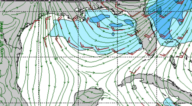
On Wednesday another cold front moves into the gulf and brings up the surf.  I can see there being surf all day Wednesday and all day Thursday.  It starts out as a southwest swell on Wednesday, gusting to 20 knots or higher.  Winds could be in excess of 20 knots on Wednesday during the day, seas reaching 5 feet or more by evening.  Thursday morning the swell will peak around 6 feet or more.  Expect highs in the mid 80s with a rain chance of about 60% on Wednesday and 40% on Thursday.  Don’t forget to check in for the surf’s up surf report to see what’s happening at the beach.

Tropical Weather Forecast: The Klotzbach Report

Phil Klotzbach and Michael Bell published their annual Hurricane season forecast on April 6th.  The report tells us what to expect for the upcoming Atlantic basin hurricane season starting on June 1st.  Through their comprehensive statistical modeling, a method that combines four different statistical models and uses hindsight verification, they generated a hurricane season output (the forecast) that’s considered the gold standard of hurricane forecasting.  From their model they are able to tell us, with a reasonable degree of reliability, how much activity we’ll see during this hurricane season.  As with most seasons and any statistical procedure, the impact of variable events like the heating of the Pacific (El Nino) presents some uncertainty.  A strong El Nino could increase the likelihood of tropical activity.  Currently, the equatorial Pacific is in the neutral El Nino state, and is expected to warm to a weak El Nino by the peak of the hurricane season.  In the report Dr. Klotzbach suggests that because the tropical Atlantic has cooled considerably over the past month, and because the far north Atlantic is relatively cold, we can expect a below average hurricane season.

The numbers:

11 named storms
50 named storm days
4 hurricanes
16 hurricane days
2 major hurricanes
4 major hurricane days

And as you may know, it’s common for the gulf to get a solid little storm right at the beginning of the season, often in June!  We may even get another epic swell like the one during Hurricane Hermine last September.


Hurricane Outlook 2016

The Colorado State University, Klotzbach hurricane outlook report has been published. The models have been run and the stats are in. Go take a look. Link below.

The document is somewhat dense, but still interesting if you can scan for the relevant information. The beginning sections of the document are sort of like a review of the methods for generating this report. The report starts to get interesting around Section 5 (ENSO) and 6 (Current Atlantic Basin Conditions). Section 5 suggests the outlook regarding El Nino vs La Nina is somewhat unsure at this early stage in the season. Section 6 says the north Atlantic is somewhat cool because of the north Atlantic oscillation, and it’s unsure at this point if the cooling will trend downward toward tropical waters. Overall the forecast numbers are about average. Section 7 reviews the season’s adjusted estimates, which is the primary output of this report.

Hurricane Outlook 2016 Report