There is a cold front coming at the end of the week. It arrives on Thursday in the afternoon. An overview of the surf forecast for the region will be available at the end of this surf forecast.
West Florida:
The general weather conditions at the coast will be similar to what we have been seeing for most of the winter. The skies will be overcast before the front on Thursday, then becoming clear behind the front as the high pressure arrives. The winds will be breezy 10-15mph from the northeast on Friday morning. The temps drop some with the arrival of the front into the upper 60s on Thrusday evening, and on Friday. The water is currently 65 degrees, and will drop a couple degrees overnight on Thursday.
Wed Morning Revision: This revision has a focus on west Florida surf. Basically, the surf will be best on Thursday. It will be another windy one. The west-northwest winds at 20-25 knots will generate head high plus surf starting around mid day on Thursday. That is the major change in the forecast. Strong north winds overnight on Thursday will bring the surf down considerably by Friday morning to knee to thigh high. The weather condition above are likely to stick.
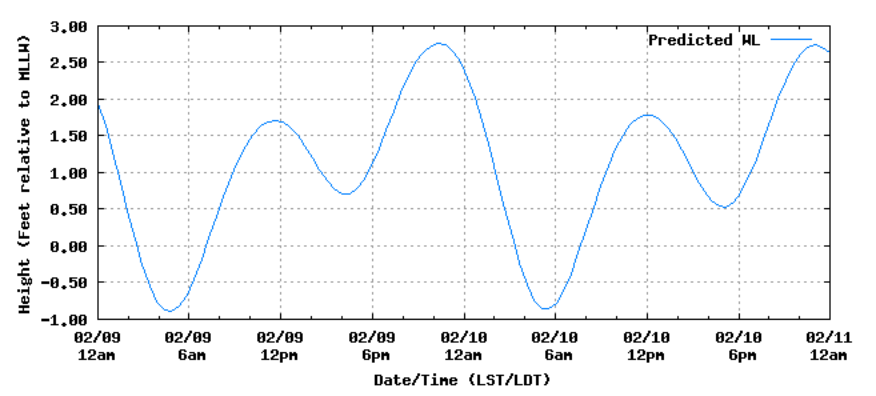
Clearwater Beach Tides:
East Florida:
Friday morning the swell comes up to around chest high, and the winds are strong offshore. The cold front swell sticks around for a day, then drops back down to around waist high or less. Just like on this side of the state the skies are overcast before the front, and clear after the front. Thurs: High of 78°, Friday: High of 70°
Panhandle:
The panhandle only gets a little wave, if anything from this front. The south flow is super mild in front of the front, so things won’t be coming up much for the area.
Texas:
The area is locked in onshore flow. A pulse this afternoon kicks up the already knee high surf to around thigh high+. By morning tomorrow the swell is all but gone. By Friday morning a significant swell fills in, around chest high. The swell continues into the beginning of next week, through Sunday, Monday, and Tuesday. The start of the upcoming surf is precipitated by strong onshore winds, gusting up to 25mph. The skies will be clear. The winds dissipate by Sunday.


