Tag Archives: weather model

Looks and Smells Like A Skunk to Me

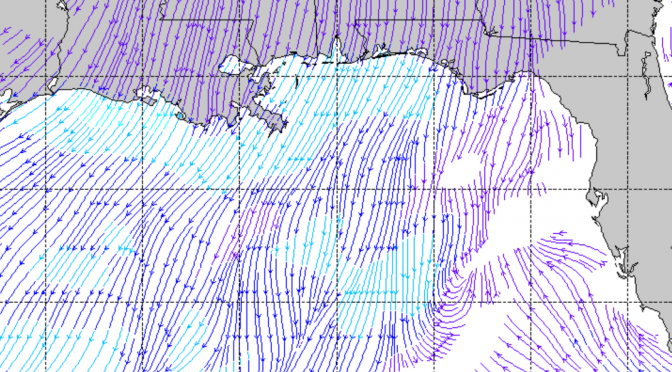
You could say another cold front is on our doorstep, but I wouldn’t. The Monday system doesn’t really look like a wave maker.  There’s some wind in front of the system pointed in the right direction without the wind speed. When the front actually gets close the winds go northeast. I can’t see this doing much if anything at this point. If anything changes I’ll let you know.

The streamline/wind speed model I just stumbled across is really cool, since the model I’ve been looking at would only show one wind barb for what must be 100+ miles of open Gulf of Mexico between here and Lousiana.  While limited in the future predictability of this model, it’s three day window should give an accurate wind depiction for short term surf forecasting.

Cold Front: (Updated Friday) Big Spring Front Number Two Sun/Mon, 04/15/18

The second big cold front of spring is just about 3 days away. As the big cold front makes its way across the gulf on Sunday morning the south winds are expected to increase. By evening, right before the front comes through, the winds turn west southwest, and could be super gusty. This model is showing sustained winds at 25 knots right along the boundary. That means even stronger gusts. The next morning, Monday morning, the winds gust onshore from the northwest, dropping through the day. There doesn’t appear to be much of a cleanup, but maybe a small glassy wave on Tuesday.

The weather temps noticeably drop behind this front. This could be a 10 degree or more drop in air temperatures. Sunday afternoon evening should still be pretty warm. Monday during the day the high drops to around 72°, with upper 50s first thing that morning. The water’s up to 73° at Pier 60, but will be dropping overnight on Sunday night. The rain coverage will be super high as the front rolls through the area.

Update: Tuesday morning will have a really fun cleanup. North winds with 3-5 foot seas.  It’s gonna be fullsuit weather with temps in the mid 50s.

The biggest surf will be Sunday right before sunset, then Monday morning. My guess is that this one will be the last big cold front of the 2017-2018 surf season.

Sunday/Monday tides:

Latest Model Run Shows A Chance of Surf This Wednesday, Thursday

What will happen this week appears to be up for discussion. Will this little front hold for long enough to keep the gradient in place on Wednesday into Thursday. Most of the runs have been showing a weak south wind before the front; then when it switches wind direction behind the front it appears to be going mostly northeast. The models seem to be out of wack this season. Every front is showing up as a northeast wind behind the front, but most of the time they’ve been wrong. Northeast winds would suggest no surf, but something is happening in the gulf where enough onshore winds have been present. Surely a pressure change is not enough to create surf, or is it?

Typically, Spring fronts are known to make surf. When the surf is in season, you can usually depend on surf to be created from a cold front. The other fairly predictable thing that we usually observe is, if there’s a cold front with enough southwest winds to make surf, you can usually bet there’s going to be a northwest swell behind it of some kind, usually at least as big as the southwest swell preceding the cold front. That last cold front was sort of the exception to the rule.

According to the latest weather model run, 15 knot west northwest wind comes up near the Louisiana/Mississippi region of the gulf and shifts eastward as the front steams along. As the front pulls out it pulls the winds to the north. This scenario is likely to create a small west or north swell sometime between Wednesday afternoon and Thursday morning.