Major Hurricane Irma is currently a category 3 hurricane with maximum sustained winds near 120 mph, with even higher gusts according to NOAA. Irma is expected to maintain its intensity for the next 5 days, if not strengthen. The ocean’s heat increases along its path, mid-level moisture is abundant, and verticle shear is low. 5 days out, as Irma approaches Florida it’s still expected to be a category 3, a very big storm.
Also, check this out: Part 2 of Hurricane Irma (Wednesday) and preparing for the storm.
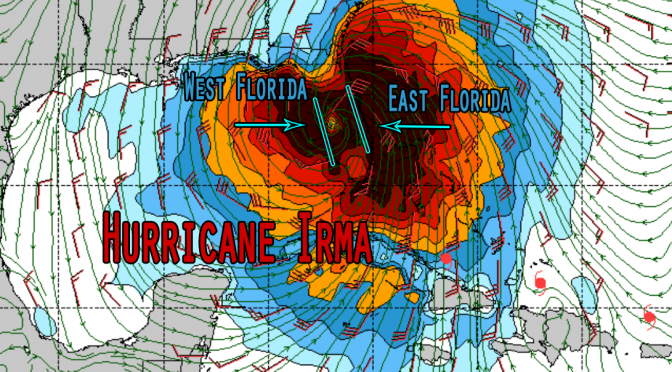
We are starting to be a little concerned about Hurricane Irma this morning. The forecast track for this storm is in great agreement. The eye of the storm tracks vertically through the state. It’s currently expected to travel along a path from the south Florida gulf up through the state; then it will begin to dissipate as it reaches Jacksonville and the Florida/Georgia border. This looks like there could be quite a few evacuations near the gulf and east coast, with almost guaranteed flooding and wind damage. Because we’re still more than a week out, there’s some question of when exactly the storm will take the northerly turn and how directly the storm will impact specific areas. But, it still looks like a big threat.
We’ll be getting surf from Hurricane Irma, for sure. An important detail of the surf forecast, the track could make a big difference. A major shift to the east and we could be able to surf cold front style northwest swell, but with the current track you’re probably going to want to either batten down the hatches or run for cover. You’re probably not going to be allowed on any of the islands, and you’re probably going to see the parks close. This looks like a substantial storm that’s currently trending toward major hurricane landfall through the state. We’ll know more on the storm as it approaches…