
The moored bouys in the Gulf of Mexico are super useful. They are useful for interpreting what is happening at the beach regarding surf, which surf spot will provide the highest quality waves for the swell direction, determining when the swell will cease to break at the beach, and even if there will be a rideable wave on smaller days. How, you ask??
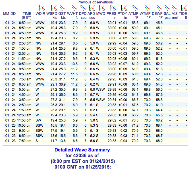
Let us first start with the bouy data chart below. You first need to be able to effectively understand the information in the chart. Across the top you will see abbreviations. These are abbreviations for the information held in the column below. For the chart below you will see, the date is January 24 (01 24). You can see, the data summaries comes in on an hourly basis from the time stamps under the heading TIME. The most important data in this chart is under the headings WVHT ft (wave height in feet), DPD sec (dominant period in seconds), APD (average period) and most important, MWD (mean wave direction). Take a moment to locate those abbreviations on the chart. When you see readings of anything with west in it that means waves are traveling from the west towards the east. The thing that really stands out about the readings from this day is the constant wave direction from 6:50 am to 6:50 pm. We see no variation from hour to hour in the direction of the swell in this chart. It remains constant from a west angle. You will see the wind blowing at that bouy shuffles around between NW and WNW. Those readings are the wind at the bouy. The dominant period (DPD), if at 8 seconds means it took 8 seconds for that bouy out in the gulf to get from the bottom of one wave to the top of that same wave. The bottom is called the trough and the top is called the crest. Wave heigh (WVHT) is measured as the distance from the trough to the crest.
Two of the most important swell directions for the gulf are called either SOUTH SWELLS or NORTH SWELLS. South swells are swells created from storms mostly in the southern region of the gulf. The swell angle will appear on the bouys as anything from ssw, sw, or wsw. North swells are swells created from storms mostly in the northern region of the gulf. These swell angles will appear on the bouys as anything from wnw, nw, or nnw. These two swell terms, north swells and south swells are important because these two swell directions are the most important factor when determining what beach will be best. That is of course next to time of the year, but we are not going to discuss time of the year in this article. Just know when swell is from the north some beaches will break best. When the swell is from the south, other beaches will be best. This makes sense because some beaches point towards the south and others point toward the north.
To make guesses about waves we must interpret more than just the direction. The combination of WVHT data column and DPD data column must also be used. The time stamp will tell you when that data was recorded at the bouy. From the northwest most bouy it takes about 6 hours for waves at that bouy to reach the beach. If bouy 42036 starts reading nw 5 feet at 7 seconds at 3 in the morning you can assume that the beaches will likely see that swell around 9 or 9:30 that same morning. You typically need at least 5 feet at 6.5 seconds to see waist high waves, but variations of long period swells, such as 1.5 feet at 11 seconds, can creates waves as well. With this information you should have a decent idea of when the gulf beaches will see waves. You can also use the readings as a way of determining if you want to wake up for a dawn patrol on a cold early morning. If the waves that might be at the beach are looking small on the chart and the water is in the upper 40s it might be a good day to sleep in. If you see the wave readings quickly drop off from 9am to 10am then you can expect a similar thing to happen about 6 hours from then.
There was recently a new buoy added to the buoy system. The newest buoy, the nearshore buoy is located 9 miles from the mouth of Tampa Bay. This buoy records wave period, height, and direction. West swell is the direction to look for. The buoy has a mimimum wave-height reading of 1 foot. We will have to watch the buoy to see how it approximates surf, but this is a good tool for determining the quality of the surf. It’s location makes it a good indicator of surf at the beaches in the northern part of Pinellas county, from right around Central Avenue all the way up to Honeymoon Island (the northernmost surfable beach).
Due to the quick rises and falls of wave size in the gulf, bouy readings are an invaluable tool for surfers in the gulf. They help us determine what beach we may want to pick for that swell direction. Most gulf surfers use these readings along with local conditions to predict their surf for the day.


