
The North Atlantic Oscillation is a phenomenon that occurs in the northern part of the Atlantic basin and affects the weather across the eastern portion of the United States. More precisely, the phenomenon is measured by determining the difference in normalized sea level pressure between two pressure centers in the North Atlantic. The northern pressure center is located near and measured at Reykjavik, Iceland, and has been since 1864. The southern pressure center is located near and measured at Lisbon, Portugal.

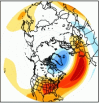
Images by NOAA (the green and brown blobs, and also the blue and red blobs are the pressure centers.)
This phenomenon is considered a telleconnection pattern, because it impacts the large scale circulation pattern over the North American continent. The term is used to denote a pattern with two modes, positive and negative (like El Nino). The fluctuations of this pattern is thought to significantly alter the alignment of the jet stream. And in the pattern we’ve had this year, this phenomenon has significantly impacted our temperatures, and surf-able frontal patterns.
During both the positive and the negative phases large scale modulations occur in the jet stream and storm tracks. It also impacts heat and moisture transport, which impacts temperature and precipitation patterns.
Of significance this year is the positive phase. The positive phase is when both the sub-polar low and subtropical high are stronger than average, resulting in a stronger jet stream and a northern shift in the strom tracks. This creates a pressure gradient in the northern Atlantic, increasing westerly winds, which subsequently decreases the amount a cold air building up in the eastern U.S. Cold air quickly flows into the northern Atlantic. During the positive phase the eastern us experiences mild and wet winter conditions.
Forecast: Still, the super El Nino is expected to exert considerable influence over the continental patterns of weather. In a usual El Nino a warm December in the gulf is followed by a colder-than-normal January through March. And NOAA believes, this winter is likely to be one of the coldest one-third of all winters in the 1981-2010 reference point.


