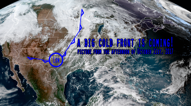
There’s a big cold front moving across the country today. The front will be in the gulf soon, but it’ll take a couple days before the surf comes up. It might be up on Tuesday afternoon with light winds, and you can bet that by Wednesday morning the surf will be solid with breezy winds from the north-northwest or northwest. The surf is likely to be in the waist to chest high range on Wednesday, potentially bigger. The surf will still be up on Thursday, dissipating through the day.
Significantly cooler arctic air is being pulled down from Canada, so expect perfect daytime temperatures behind the front on Wednesday and Thursday. The temperatures might even be a bit on the cool side. The water temperature will also be dropping quick from its current 78° mark. When the surf starts filling in you may only need boardshorts or a springsuit, but by late in the window of surf you might need a 3 mil fullsuit especially closer to dark or early in the mornings particularly when the cold air is gusting to 20 knots.
As we begin the surfing season I would recommend you try to surf at least a couple of these early season cold fronts. This time of year the sandbars are usually in really nice shape and the low tides are mostly higher tides. The first cold fronts of the season have exceptionally comfortable temperatures if you come prepared with the right thickness of wetsuit, and you’ll usually find really fun quality waves.


