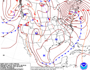
On saturday, after the low drags the cool air mass across the gulf, we are still looking at a powerful 988 millibar low pressure system in the northeast, and a cold front boundary almost as far south as the Pacific Ocean.

~Weekend Cold Front~
Continue reading Strong Cold Front This Weekend 10.08.16
Red tide is engulfing the coastline after a nasty wastewater spill may have triggered an intense algal bloom. Hurricane Hermine made landfall on the northern gulf coast of Florida on September second. The repeated bouts of rain put many of the aging sewage systems into overload. Even with sewage plants purging water pre-storm, the sewage systems became overloaded. Wastewater was lost into Tampa Bay, wastewater that was quickly washed into the gulf. Wastewater can be a trigger for the naturally occurring Red Tide (K. brevis) blooms. Continue reading Wastewater Triggered Red Tide (K. brevis)
The surf is about knee high here at Sand Key. The surf might get a bit better after the tide change in 20 minutes. More images below. Continue reading Surf Report Photo: 09.29.16
Many of the models are hinting at a decent wave tomorrow. Some are still unsure. The wind model is suggesting the winds in the gulf Continue reading Surf Forecast 09.28.16
Last night a storm developed from the East putting on a beautiful display of Mother Natures raw power. Flash lightning was firing nearly every second for around a half hour. It seemed like the world Continue reading Electric Skies Over AMI: 9/26/16 Lightning Storms
The cold front over Louisiana is projected to get into the gulf. It is going to be close to west Florida. Will it impact west Florida’s weather? The rain chances go up, but that is about it. It is forecast to transform from Continue reading Mid-September Cold Front